
We are in hot water…
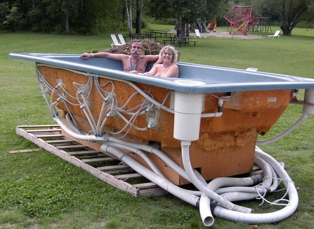
Well, almost! The hot tub has now been delivered and should be installed in the next few weeks. The Hydropool H-1200 is a 12 person commercial hot tub. Here are some specifications:
144″x 92″x 42″deep / 366 x 234 x 107 cm
Height: 42″ / 107 cm
Volume: @866 US gallons / 3275 Litres
As well, our shipment of on-demand hot water heathers have also been received. Once installed, they will provide an endless supply of hot water at both the Beckett Circle showers and in the clubhouse. They are also more environmentally-friendly because they use less energy – hot water is only heated when required.
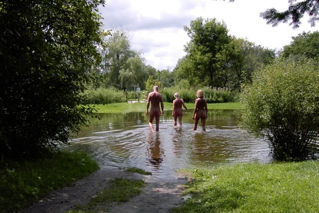 Speaking of water, the area around Bare Oaks Family Naturist Park experienced several small deluges last Sunday and Monday. As a result, the Black River flooded over its banks. That normally only happens during the spring run off. The Black River is an important watershed in this area. The following is an excerpt from State of the Watershed Report: Black River Subwatershed, by the Lake Simcoe Region Convervation Authority:
The Black River Subwatershed
The Black River Subwatershed is located south of Lake Simcoe in approximately the centre of the watershed. The main tributaries of the Black River include Harrison Creek, Mount Albert Creek, Vivian Creek and Zephyr Creek. The Black River Subwatershed drains an area approximately 325 km2 in size. The main tributaries of the Subwatershed include Harrison  Creek, Mount Albert Creek, Vivian Creek and Zephyr Creek. As with many of the subwatersheds south of Lake Simcoe, the headwaters of the Black River originate in the Oak Ridges Moraine.
The Black River Subwatershed is primarily a rural subwatershed with agriculture as the main land use. Good forest cover still exists throughout much of the subwatershed. There are several communities throughout the Subwatershed including Sharon, Holt, Mount Albert, Zephyr, Brown Hill, Baldwin and Sutton. The Subwatershed lies in the municipalities of Whitchurch-Stouffville, East Gwillimbury, Georgina and Uxbridge. This includes two regional municipalities, specifically York and Durham Regions. The Subwatershed ecosystem has felt the impact of human activities associated with changes in land use and development. It is therefore relevant to briefly examine the history of the Black River Subwatershed to appreciate these changes.The History of the Black River Subwatershed
The Black River Subwatershed saw some of its first human inhabitants after the retreat of the Wisconsin Glacier more than 3,500 years ago. The native inhabitants included nomadic hunters, the Laurentian Indians and the Woodland Indians. Just prior to the arrival of the Europeans, the Iroquois occupied the region. This group had a strong presence in the area since the 12th Century.
 Settlement of the area began in the 1790’s in the southern headwater areas of the Black River Subwatershed but it was not until the 1820’s that settlements reached the mouth of the river. In 1821, Samuel and Rufus Birchard settled along a tributary of the Black River in what is present day Mount Albert. The community that grew around them was originally called Birchardtown, then shortly there after changed to Newlands. In 1860, to honour the Prince of Wales visit to the area, the name was changed a last time to Mount Albert.
One of the first settlers in the northern portion of the Subwatershed was Capt. William Bourchier after which the first community in the area was named, Bourchier’s Mills (later named Sutton). Jackson’s Point was also originally named after Bourchier until he sold the land to his father-in-law John Mills Jackson.
William Bourchier’s namesakes grew rapidly due in no small measure to their close proximity to Lake Simcoe. The Lake not only supported a healthy fishery, was a port for schooners and steamers, but was also renowned for its ice which was shipped as far as the United States. Tourism also developed into a major industry for the area and when the Radial Railway came to the area, it brought some of Ontario’s first cottagers and seasonal residents as well.
Throughout the rest of the Black River Subwatershed, industry in those early years, was understandably resource based with logging and agriculture being the main industries. The logging industry was advanced considerably by the coming of the railroad, so much so that within 50 years the area was mostly stripped of Detrimental effects of deforestation. (Durham Region, 1930’s) marketable lumber. Due to this over logging, the ability of the land to store water was lost and severe spring flooding resulted. The summers brought intense droughts to the area and wind erosion was so severe that some roads were blocked by the shifting sands. To mitigate these impacts a reforestation program was adopted in 1911, with the passing of the Counties Reforestation Act, and subsequently by the Reforestation Act, which was passed in 1921. The Reforestation Act enabled the establishment of tree nurseries and the supply of tree seedlings, in addition to planting and management by the province. Counties were able to purchase barren farmland and place it under “management agreement” with the Department of Lands and Forests. This eventually led to the establishment of municipally run reforestation areas such as York Regional Forest tracts which exist today.
Agriculture has remained as one of the prominent land uses in the Black River Subwatershed, however, agricultural practices have changed over time. The small mixed crop homestead type farms were replaced as new machinery allowed farmers to increase production. During the forty year period between 1941 and 1981, the number of farms throughout the area decreased significantly. This was due to a cycle of economic pressure to produce more for less which forced farmers to adopt new farming methods and practices. The use of chemical fertilisers to improve crop yield had become a common practice, livestock operations increased the size of their herds and fence rows were removed to create larger fields. The net effect was fewer, larger, very intensively managed farms which used up soil resources and concentrated livestock waste.
Today, the Subwatershed is home to a number of small communities including Sutton and Mount Albert. While there is growth planned for both Sutton and Mount Albert, the Black River Subwatershed will largely remain as it has for the past 100 years, a mainly rural agricultural area.